PROJECTS
The WILL Claim, GoldbrIDGE B.C.
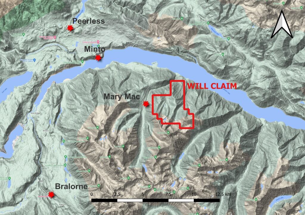
WestKam Gold Corp. has a 100% undivided interest in the Will mineral claim number 1100561 as shown below. The claim covers 1142.47ha and is good standing until January 17, 2024.
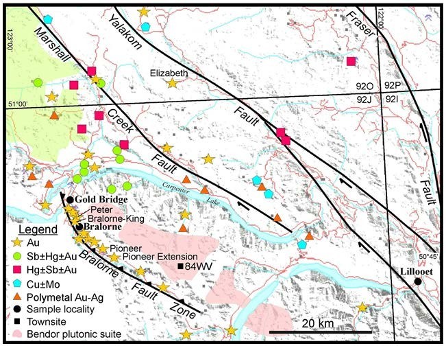
The property is situated within the Bridge River mining district in southwestern British Columbia. The geological setting and metallogeny of the region is described by Hart et al. (2008) and Church and Jones (1999). The regional geology is shown in Figure 2. Figure 3 is a map of the Bridge River Camp showing the major faults and mineral deposits.
The Bridge River district is situated at a tectonic boundary between the Cache Creek and Stikine allochthonous terranes. The Bridge River Terrane is possibly equivalent to the Cache Creek Terrane and comprises slabs of oceanic and transitional crust that were stacked against the continental margin together with island-arc-related units of the Cadwallader Terrane, interpreted as part of the Stikine Terrane. Diverse rock units of these two terranes are structurally deformed and imbricated in the area, together with
large fault-bounded slices of gabbroic and ultramafic rocks. These early structures are crosscut by later northwest- and north-trending major faults related to the Fraser-Yalakom regional dextral strike slip fault system, and by Late Cretaceous and Tertiary granitic plutons and related dikes (Church, 1996). The Bridge River Terrane comprises Mississippian to Middle Jurassic accretionary complexes of oceanic basalt and gabbro
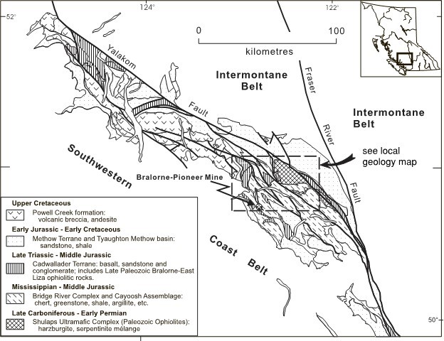
Triassic to Early Jurassic island arc volcanic rocks and mostly marine, arc- marginal clastic strata of the Cadwallader Terrane. These assemblages are variably overlain, mostly to the north, by clastic, mostly non-marine successions belonging to the Jurassic- Cretaceous Tyaughton Basin (Har t et. al., 2008). The region has been intruded by a wide range of Cretaceous and Tertiary plutonic and volcanic rocks and their hypabyssal equivalents. Most significant among these are the dominantly Cretaceous granitoid bodies that form the Coast Plutonic Complex (CPC), which is locally characterized by the 92 Ma Dickson McClure intrusions, and the large individual bodies of the Late Cretaceous Bendor plutonic suite. Hypabyssal magmatism is reflected by emplacement of porphyritic dikes between 84 and 66 Ma, with the youngest magmatic event being 44 Ma lamprophyre dikes (Hart et. al., 2008).
The district has been deformed by mid-Cretaceous contractional deformation within the westerly trending Shulaps thrust belt, and by contractional and oblique-sinistral deformation associated with the Bralorne-Eldorado fault system. The timing of this deformation and metamorphism is ca. 130 to 92 Ma, with synorogenic sedimentary flysch, as young as mid-Cretaceous, cut by the faults (Hart et. al., 2008). The Bridge River and Cadwallader Terrane are juxtaposed along the Bralorne- Eldorado fault system, which in the Bridge River area consists of linear, tectonized and serpentinized slices of late Paleozoic mafic and ultramafic rocks known as the Bralorne-East Liza Lake thrust belt, a 1 to 3 km wide zone defined by Schiarizza et al., 1997.
The main gold-forming event in the Bridge River district took place at ca. 68 to 64 Ma at the Bralorne-Pioneer deposit (Hart et. al., 2008). Mineralization pre-dated or was synchronous with the emplacement of the Bendor batholith, and the gold event overlaps initiation of dextral strike- slip on the regional fault systems in this region. The abundance of gold, antimony, and mercury deposits and occurrences along the various main structures in the district suggests that the onset of dextral strike-slip in this part of the Cordillera facilitated widespread fluid flow along the reactivated fault systems (Hart et. al., 2008).
Regionally the area is known for the Bralorne-Pioneer gold-bearing veins. These veins were deposited from low salinity fluids at 300°C to 400°C and 1.25 kbar to 1.75 kbar (Leitch, 1989). The vein style, structure, mineralogy, and alteration are all similar to those defined for orogenic gold deposits (Groves et al., 1998).
These gold deposits, therefore, belong to a well-recognized group of deposits referred to as mesothermal, orogenic or greenstone-hosted quartz-carbonate gold vein deposits. These deposits include the Mother Lode district in California and most of the greenstone-hosted gold deposits in the Canadian Shield, including the Timmins, Val d’Or and Red Lake camps. These deposits are quartz-carbonate veins hosted in moderately to steeply dipping brittle-ductile shear zones and, locally, in shallow dipping extensional fractures.
The Minto Mine, 7.5 kilometers to the northwest on the same strike, operated from 1934 to 1940. During its operation 2130 metres of underground work was done, and a total of 80,650 tonnes (88,900 tons) of ore grading 6.8 grams of gold and 19.9 grams of silver per tonne was produced, totalling 546 kilograms (17,558 ounces) of gold and 1,573 kilograms (50,582 ounces) of silver, 9,673 kilograms of copper and 56,435 kilograms of lead.
The closest project of significance and similar geological setting is the Mary Mac, 1 kilometer to the northwest. In several adits and workings an earlier molybdenum phase of mineralization, associated with a hornblende feldspar porphyry, is over printed by later stibnite-gold veins. In 1974 a small antimony mill was operated at a capacity of 4 tonnes per day. Drilling In 1983, indicated reserves for the Main zone were reported to be 22,300 tonnes grading 7.4338 grams per tonne gold or 78,500 tonnes of ore grading 2.8927 grams per tonne. Indicated reserves for the North zone in 1983 were reported to be 10,800 tonnes grading 5.256 grams per tonne gold or 39,200 tonnes grading 2.3328 grams per tonne gold (Assessment Report 11647).